
Make a donation
Gear up for your next adventure:
As an Amazon Associate, this site earns from qualifying purchases at no extra cost to you.
Mouchin topographic map
Click on the map to display elevation.
Make a donation
Gear up for your next adventure:
As an Amazon Associate, this site earns from qualifying purchases at no extra cost to you.
About this map
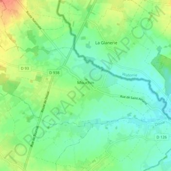
Name: Mouchin topographic map, elevation, terrain.
Average elevation: 128 ft
Minimum elevation: 75 ft
Maximum elevation: 223 ft
Make a donation
Gear up for your next adventure:
As an Amazon Associate, this site earns from qualifying purchases at no extra cost to you.
Other topographic maps
Click on a map to view its topography, its elevation and its terrain.
Lille
Frankreich > Nordfrankreich > Nord > Lille
Die Stadt Lille befindet sich auf einer Höhe von circa 20 m in einer Ausbuchtung des Deûle-Tals. An dieser Stelle tauchen die letzten, senonischen und turonischen Kreide-Aufschlüsse des Mélantois-Naturraums unter die Hügellandschaften der Weppes im Westen und des Barœul im Norden, die sich im…
Average elevation: 105 ft
Make a donation
Gear up for your next adventure:
As an Amazon Associate, this site earns from qualifying purchases at no extra cost to you.