
Thank you for supporting this site ❤️
Make a donation
Make a donation
Gear up for your next adventure:
As an Amazon Associate, this site earns from qualifying purchases at no extra cost to you.
Fossat topographic map
Click on the map to display elevation.
Thank you for supporting this site ❤️
Make a donation
Make a donation
Gear up for your next adventure:
As an Amazon Associate, this site earns from qualifying purchases at no extra cost to you.
About this map
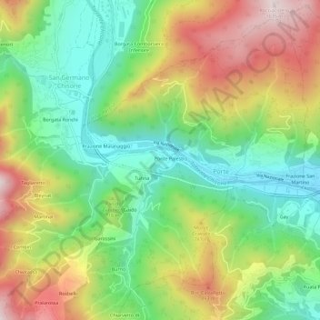
Name: Fossat topographic map, elevation, terrain.
Location: Fossat, San Germano Chisone, Turin, Piémont, 10065, Italie (44.86868 7.23727 44.90868 7.27727)
Average elevation: 2,172 ft
Minimum elevation: 1,335 ft
Maximum elevation: 3,366 ft
Thank you for supporting this site ❤️
Make a donation
Make a donation
Gear up for your next adventure:
As an Amazon Associate, this site earns from qualifying purchases at no extra cost to you.