
Make a donation
Gear up for your next adventure:
As an Amazon Associate, this site earns from qualifying purchases at no extra cost to you.
Offelten topographic map
Click on the map to display elevation.
Make a donation
Gear up for your next adventure:
As an Amazon Associate, this site earns from qualifying purchases at no extra cost to you.
About this map
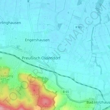
Name: Offelten topographic map, elevation, terrain.
Average elevation: 233 ft
Minimum elevation: 164 ft
Maximum elevation: 614 ft
Make a donation
Gear up for your next adventure:
As an Amazon Associate, this site earns from qualifying purchases at no extra cost to you.
Other topographic maps
Click on a map to view its topography, its elevation and its terrain.
Eininghausen
Deutschland > Nordrhein-Westfalen > Kreis Minden-Lübbecke > Preußisch Oldendorf
Average elevation: 499 ft
Getmold
Deutschland > Nordrhein-Westfalen > Kreis Minden-Lübbecke > Preußisch Oldendorf
Average elevation: 171 ft
Börninghausen
Deutschland > Nordrhein-Westfalen > Kreis Minden-Lübbecke > Preußisch Oldendorf
Aufgrund der im Altkreis Lübbecke einzigartigen topografischen Lage, spielt der Tourismus eine überdurchschnittliche Rolle.
Average elevation: 443 ft
Fiegenburg
Deutschland > Nordrhein-Westfalen > Kreis Minden-Lübbecke > Preußisch Oldendorf > Fiegenburg
Average elevation: 397 ft
Make a donation
Gear up for your next adventure:
As an Amazon Associate, this site earns from qualifying purchases at no extra cost to you.