
Make a donation
Gear up for your next adventure:
As an Amazon Associate, this site earns from qualifying purchases at no extra cost to you.
Borgoratto topographic map
Click on the map to display elevation.
Make a donation
Gear up for your next adventure:
As an Amazon Associate, this site earns from qualifying purchases at no extra cost to you.
About this map
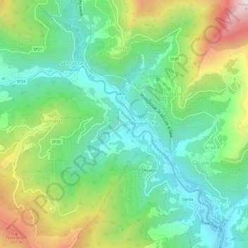
Name: Borgoratto topographic map, elevation, terrain.
Location: Borgoratto, Lucinasco, Imperia, Liguria, 18027, Italia (43.94746 7.96006 43.98746 8.00006)
Average elevation: 1,178 ft
Minimum elevation: 256 ft
Maximum elevation: 3,045 ft
Make a donation
Gear up for your next adventure:
As an Amazon Associate, this site earns from qualifying purchases at no extra cost to you.
Other topographic maps
Click on a map to view its topography, its elevation and its terrain.
Olivetta San Michele
Italia > Liguria > Imperia > Fanghetto
Il paese capoluogo di Olivetta è collocato nella valle del torrente Bevera, lungo un pendio collinare avente un'altitudine media di 292 metri sul livello del mare; il punto più in alto del territorio olivettese è posizionato alla vetta del monte Buletta (1328 m). Oltre al torrente Bevera, il comune è…
Average elevation: 1,424 ft