Geolocate

Colony topographic map

Click on the map to display elevation.

About this map

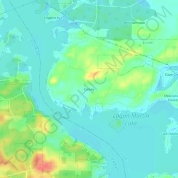
Name: Colony topographic map, elevation, terrain.

Location: Colony, Lincoln, Talladega County, Alabama, United States (33.54510 -86.21914 33.58510 -86.17914)

Average elevation: 495 ft

Minimum elevation: 449 ft

Maximum elevation: 620 ft

Talladega County trails, hiking, mountain biking, running and outdoor activities

Gear up for your next adventure:

🪑Ultralight Camp Chairs - Portable seating for resting after a long day of mapping
📦Gear Storage Bags - Organize and protect outdoor equipment
🪵Folding Camp Saw - Compact saw for wood and campsite work
🧤Hiking Gloves - Protective gloves for rugged trails
🛰️Handheld GPS Units - Professional satellite navigators for precise backcountry mapping

As an Amazon Associate, this site earns from qualifying purchases at no extra cost to you.