Geolocate

Edinburg topographic map

Click on the map to display elevation.

About this map

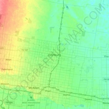
Name: Edinburg topographic map, elevation, terrain.

Location: Edinburg, Hidalgo County, Texas, 78540, United States (26.14140 -98.32245 26.46140 -98.00245)

Average elevation: 108 ft

Minimum elevation: 52 ft

Maximum elevation: 249 ft

Gear up for your next adventure:

🧥Waterproof Jacket for Hiking - Breathable and rugged rain jacket for outdoor excursions
🚪Portable Camp Chair - Foldable chair for comfort at camp
📚Navigation Handbooks - Master the art of reading topographic maps and using a compass
📖Nature Tracking Books - Learn to track wildlife and terrain
📦Gear Storage Bags - Organize and protect outdoor equipment

As an Amazon Associate, this site earns from qualifying purchases at no extra cost to you.