
Salinas topographic map
Click on the map to display elevation.
About this map
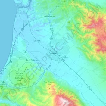
Name: Salinas topographic map, elevation, terrain.
Location: Salinas, Monterey County, California, 93901, United States (36.51441 -121.81504 36.83441 -121.49504)
Average elevation: 482 ft
Minimum elevation: -23 ft
Maximum elevation: 3,543 ft
Monterey County trails, hiking, mountain biking, running and outdoor activities
Other topographic maps
Click on a map to view its topography, its elevation and its terrain.