
Make a donation
Gear up for your next adventure:
As an Amazon Associate, this site earns from qualifying purchases at no extra cost to you.
Bolland topographic map
Click on the map to display elevation.
Make a donation
Gear up for your next adventure:
As an Amazon Associate, this site earns from qualifying purchases at no extra cost to you.
About this map
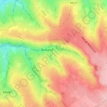
Name: Bolland topographic map, elevation, terrain.
Location: Bolland, Herve, Verviers, Liège, Wallonie, 4650, Belgique (50.64077 5.73002 50.67937 5.77988)
Average elevation: 797 ft
Minimum elevation: 535 ft
Maximum elevation: 1,001 ft
Make a donation
Gear up for your next adventure:
As an Amazon Associate, this site earns from qualifying purchases at no extra cost to you.
Other topographic maps
Click on a map to view its topography, its elevation and its terrain.
Charneux
Belgique > Liège > Verviers > Herve
Le village se situe à une altitude moyenne de 230 mètres. Il a une superficie de 1443 hectares, et comprend les hameaux et dépendances suivants : Renoupré, Warrimont, Wadeleux, Val-Dieu, Neuf-Moulin, Larbuisson, Bouxhmont, Asse, Cerfontaine, Plenesse, Champiomont, Privot, Fastré, Sironval, Faweux, Try,…
Average elevation: 797 ft
Make a donation
Gear up for your next adventure:
As an Amazon Associate, this site earns from qualifying purchases at no extra cost to you.