
Thank you for supporting this site ❤️
Make a donation
Make a donation
Gear up for your next adventure:
As an Amazon Associate, this site earns from qualifying purchases at no extra cost to you.
Biwong-Bane topographic map
Click on the map to display elevation.
Thank you for supporting this site ❤️
Make a donation
Make a donation
Gear up for your next adventure:
As an Amazon Associate, this site earns from qualifying purchases at no extra cost to you.
About this map
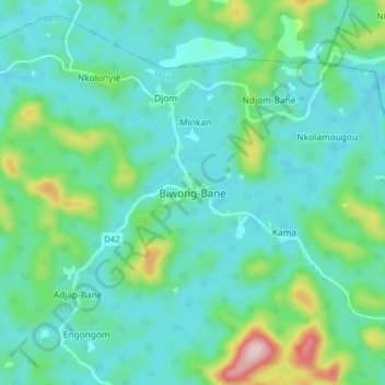
Name: Biwong-Bane topographic map, elevation, terrain.
Location: Biwong-Bane, Biwong-Bané, Mvila, Région du Sud, Cameroun (3.08642 11.10791 3.16642 11.18791)
Average elevation: 2,441 ft
Minimum elevation: 2,201 ft
Maximum elevation: 3,353 ft
Thank you for supporting this site ❤️
Make a donation
Make a donation
Gear up for your next adventure:
As an Amazon Associate, this site earns from qualifying purchases at no extra cost to you.