Geolocate

Pangea topographic map

Click on the map to display elevation.

About this map

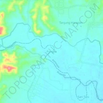
Name: Pangea topographic map, elevation, terrain.

Location: Pangea, Gorontalo, Sulawesi, Indonesia (0.73328 122.45128 0.77328 122.49128)

Average elevation: 171 ft

Minimum elevation: 105 ft

Maximum elevation: 486 ft

Other topographic maps

Click on a map to view its topography, its elevation and its terrain.

Sungai Paguyaman

Indonesia > Gorontalo > Gorontalo

Average elevation: 85 ft

Gear up for your next adventure:

🥤Water Filter Bottle - All‑in‑one filter bottle for safe hydration
🧣Hiking Neck Gaiter - Multi‑use neck protection for outdoor weather
🌲Outdoor Survival Books - Best books on survival skills
🧥Men's Rain Shells - Premium waterproof and breathable jackets for mountain weather
🔋Rechargeable Batteries - Power up your outdoor devices

As an Amazon Associate, this site earns from qualifying purchases at no extra cost to you.