
Thank you for supporting this site ❤️
Make a donation
Make a donation
Gear up for your next adventure:
As an Amazon Associate, this site earns from qualifying purchases at no extra cost to you.
Welscheid topographic map
Click on the map to display elevation.
Thank you for supporting this site ❤️
Make a donation
Make a donation
Gear up for your next adventure:
As an Amazon Associate, this site earns from qualifying purchases at no extra cost to you.
About this map
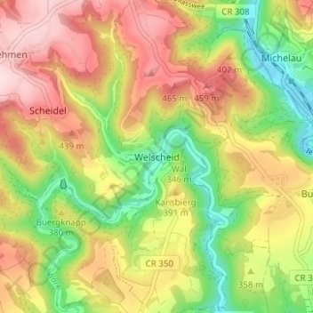
Name: Welscheid topographic map, elevation, terrain.
Location: Welscheid, Bourscheid, Canton Diekirch, 9191, Luxembourg (49.86695 6.04558 49.90695 6.08558)
Average elevation: 1,181 ft
Minimum elevation: 702 ft
Maximum elevation: 1,660 ft
Thank you for supporting this site ❤️
Make a donation
Make a donation
Gear up for your next adventure:
As an Amazon Associate, this site earns from qualifying purchases at no extra cost to you.