Geolocate

Epen topographic map

Click on the map to display elevation.

About this map

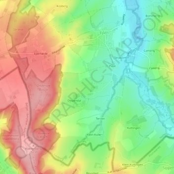
Name: Epen topographic map, elevation, terrain.

Location: Epen, Gulpen-Wittem, Limburg, Netherlands (50.75037 5.88347 50.78223 5.93576)

Average elevation: 554 ft

Minimum elevation: 351 ft

Maximum elevation: 823 ft

Gear up for your next adventure:

GPS Sports Watch - GPS watch for running, hiking and training
🎒Trail Energy Bars - High‑calorie bars for hiking energy
🔭Compact Binoculars - HD vision for scouting terrain and identifying distant landmarks
📱Solar Portable Charger - Solar power bank for charging devices off‑grid
📡Handheld GPS Device - Reliable handheld GPS for outdoor navigation

As an Amazon Associate, this site earns from qualifying purchases at no extra cost to you.