
San Geronimo topographic map
Click on the map to display elevation.
San Geronimo
San Geronimo (Spanish: San Gerónimo, meaning "St. Jerome") is a census-designated place (CDP) located in the San Geronimo Valley in Marin County, California in the United States. San Geronimo is located with Lagunitas-Forest Knolls to its west, Woodacre to its east, and 8 miles (13 km) southwest of downtown Novato, at an elevation of 292 feet (89 m). The population was 446 at the 2010 census.
About this map
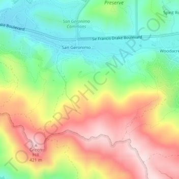
Name: San Geronimo topographic map, elevation, terrain.
Location: San Geronimo, Marin County, California, United States (37.99689 -122.68045 38.01638 -122.64495)
Average elevation: 768 ft
Minimum elevation: 262 ft
Maximum elevation: 1,391 ft
Marin County trails, hiking, mountain biking, running and outdoor activities
Other topographic maps
Click on a map to view its topography, its elevation and its terrain.
Corte Madera
United States > California > Marin County
Corte Madera (/ˈkɔːrtə məˈdɛrə/; Spanish for "Chop Wood") is an incorporated town in Marin County, California. Corte Madera is located 3.25 miles (5.2 km) south of San Rafael, at an elevation of 39 feet (12 m). The population was 10,222 at the 2020 census. The town was named after the Spanish…
Average elevation: 171 ft
Baltimore Park
United States > California > Marin County > Larkspur > Larkspur > Baltimore Park
Average elevation: 190 ft
San Anselmo
United States > California > Marin County
San Anselmo (Spanish for '"Saint Anselm"') is an incorporated town in Marin County, California, United States. San Anselmo is located 1.5 miles (2.4 km) west of San Rafael, at an elevation of 46 feet (14 m). It is located about 20 miles (32 km) north of San Francisco. The town is bordered by San Rafael to the…
Average elevation: 325 ft
Golden Gate National Recreation Area
United States > California > Marin County
Average elevation: 492 ft
San Quentin
United States > California > Marin County
San Quentin (Spanish: San Quintín, meaning "St. Quentin") is a small unincorporated community in Marin County, California, United States. It is located west of Point San Quentin, at an elevation of 30 feet (9.1 meters).
Average elevation: 10 ft
Tamalpais-Homestead Valley
United States > California > Marin County > Mill Valley
Average elevation: 302 ft