Geolocate

Soldotna topographic map

Click on the map to display elevation.

About this map

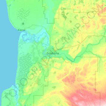
Name: Soldotna topographic map, elevation, terrain.

Location: Soldotna, Kenai Peninsula, Alaska, United States (60.32472 -151.22535 60.64472 -150.90535)

Average elevation: 207 ft

Minimum elevation: -7 ft

Maximum elevation: 843 ft

Kenai Peninsula trails, hiking, mountain biking, running and outdoor activities

Gear up for your next adventure:

🧺Microfiber Travel Towels - Compact and fast-drying towels for trail use
Backpacking Tents - Weight-optimized shelters for multi-day topographic surveys
🌡️Portable Weather Meter - Track weather conditions on the trail
🪶Multi‑Purpose Knife - Useful blade for camp and trail
🎒Outdoor Daypacks - Lightweight backpacks designed for carrying maps and essential gear

As an Amazon Associate, this site earns from qualifying purchases at no extra cost to you.