
Make a donation
Gear up for your next adventure:
As an Amazon Associate, this site earns from qualifying purchases at no extra cost to you.
Javier topographic map
Click on the map to display elevation.
Make a donation
Gear up for your next adventure:
As an Amazon Associate, this site earns from qualifying purchases at no extra cost to you.
Javier
La localidad de Javier está situada en la parte oriental de La Comunidad Foral de Navarra, a una altitud de 465 msnm. Su término municipal tiene una superficie de 46,7 km² divido en dos partes separadas por el término municipal de Sangüesa: la zona propia e históricamente de Javier y el término del antiguo pueblo de Peña.
Make a donation
Gear up for your next adventure:
As an Amazon Associate, this site earns from qualifying purchases at no extra cost to you.
About this map
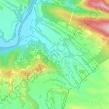
Name: Javier topographic map, elevation, terrain.
Location: Javier, Navarra, España (42.57119 -1.22869 42.61119 -1.18869)
Average elevation: 1,650 ft
Minimum elevation: 1,348 ft
Maximum elevation: 2,260 ft
Make a donation
Gear up for your next adventure:
As an Amazon Associate, this site earns from qualifying purchases at no extra cost to you.