
Make a donation
Gear up for your next adventure:
As an Amazon Associate, this site earns from qualifying purchases at no extra cost to you.
Les Groules topographic map
Click on the map to display elevation.
Make a donation
Gear up for your next adventure:
As an Amazon Associate, this site earns from qualifying purchases at no extra cost to you.
About this map
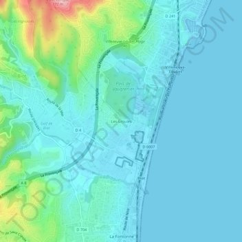
Name: Les Groules topographic map, elevation, terrain.
Average elevation: 85 ft
Minimum elevation: -3 ft
Maximum elevation: 538 ft
Make a donation
Gear up for your next adventure:
As an Amazon Associate, this site earns from qualifying purchases at no extra cost to you.
Other topographic maps
Click on a map to view its topography, its elevation and its terrain.
Marineland
France > Provence-Alpes-Côte d'Azur > Alpes-Maritimes > Antibes > Les Groules
Average elevation: 30 ft
Jardin de la Pinède
France > Provence-Alpes-Côte d'Azur > Alpes-Maritimes > Antibes
Average elevation: 43 ft
Jardin René Cassin
France > Provence-Alpes-Côte d'Azur > Alpes-Maritimes > Antibes
Average elevation: 62 ft
Plage de Ponteil
France > Provence-Alpes-Côte d'Azur > Alpes-Maritimes > Antibes
Average elevation: 46 ft
Make a donation
Gear up for your next adventure:
As an Amazon Associate, this site earns from qualifying purchases at no extra cost to you.