
Make a donation
Gear up for your next adventure:
As an Amazon Associate, this site earns from qualifying purchases at no extra cost to you.
Levi Ski Resort topographic map
Click on the map to display elevation.
Make a donation
Gear up for your next adventure:
As an Amazon Associate, this site earns from qualifying purchases at no extra cost to you.
About this map
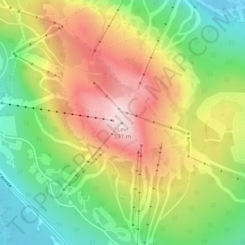
Name: Levi Ski Resort topographic map, elevation, terrain.
Average elevation: 1,109 ft
Minimum elevation: 627 ft
Maximum elevation: 1,732 ft
Make a donation
Gear up for your next adventure:
As an Amazon Associate, this site earns from qualifying purchases at no extra cost to you.
Other topographic maps
Click on a map to view its topography, its elevation and its terrain.
Kittilä
The ski resort Levi is situated in the village of Sirkka, Kittilä on Levi Fell (in Finnish "Levitunturi") (elevation 531 metres (1742 feet)). The resort hosts a slalom event early each season on the Alpine World Cup circuit and offers both downhill and cross-country skiing to the public, as well as snow…
Average elevation: 833 ft