
Make a donation
Gear up for your next adventure:
As an Amazon Associate, this site earns from qualifying purchases at no extra cost to you.
Pavia Township topographic map
Click on the map to display elevation.
Make a donation
Gear up for your next adventure:
As an Amazon Associate, this site earns from qualifying purchases at no extra cost to you.
About this map
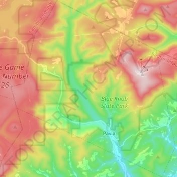
Name: Pavia Township topographic map, elevation, terrain.
Location: Pavia Township, Bedford County, Pennsylvania, United States (40.23434 -78.65187 40.32703 -78.53887)
Average elevation: 2,182 ft
Minimum elevation: 1,316 ft
Maximum elevation: 3,140 ft
Bedford County trails, hiking, mountain biking, running and outdoor activities
Make a donation
Gear up for your next adventure:
As an Amazon Associate, this site earns from qualifying purchases at no extra cost to you.
Other topographic maps
Click on a map to view its topography, its elevation and its terrain.
Breezewood
United States > Pennsylvania > Bedford County > East Providence Township
Average elevation: 1,355 ft
New Enterprise
United States > Pennsylvania > Bedford County > South Woodbury Township
Average elevation: 1,302 ft
Blue Knob
United States > Pennsylvania > Bedford County > Pavia Township
Blue Knob (elevation 3,146 feet (959 m)) is a summit in the eastern United States with a broad dome that is the northernmost 3,000-footer in the Allegheny Mountains. It is the highest point in Bedford County, Pennsylvania.
Average elevation: 2,598 ft
Stiefler Corner
United States > Pennsylvania > Bedford County > Kimmel Township
Average elevation: 1,706 ft
Make a donation
Gear up for your next adventure:
As an Amazon Associate, this site earns from qualifying purchases at no extra cost to you.
Abbot Ridge
United States > Pennsylvania > Bedford County > Liberty Township
Average elevation: 958 ft
Yellow Creek
United States > Pennsylvania > Bedford County > Hopewell Township > Yellow Creek
Average elevation: 1,060 ft
State Line
United States > Pennsylvania > Bedford County > Londonderry Township
Average elevation: 1,079 ft
Chaneysville
United States > Pennsylvania > Bedford County > Southampton Township
Average elevation: 1,224 ft
Make a donation
Gear up for your next adventure:
As an Amazon Associate, this site earns from qualifying purchases at no extra cost to you.
Madley
United States > Pennsylvania > Bedford County > Londonderry Township
Average elevation: 1,542 ft
Blue Knob
United States > Pennsylvania > Bedford County > Pavia Township
Blue Knob (elevation 3,146 feet (959 m)) is a summit in the eastern United States with a broad dome that is the northernmost 3,000-footer in the Allegheny Mountains. It is the highest point in Bedford County, Pennsylvania.
Average elevation: 2,598 ft
Make a donation
Gear up for your next adventure:
As an Amazon Associate, this site earns from qualifying purchases at no extra cost to you.