Geolocate

Great Casterton topographic map

Click on the map to display elevation.

About this map

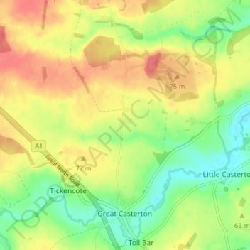
Name: Great Casterton topographic map, elevation, terrain.

Location: Great Casterton, Rutland, England, United Kingdom (52.66635 -0.55907 52.70208 -0.49481)

Average elevation: 207 ft

Minimum elevation: 108 ft

Maximum elevation: 302 ft

Other topographic maps

Click on a map to view its topography, its elevation and its terrain.

Toll Bar

United Kingdom > England > Rutland

Average elevation: 200 ft

Cold Overton

United Kingdom > England > Rutland > Melton

Average elevation: 561 ft

Oakham Canal

United Kingdom > England > Rutland > Oakham

Average elevation: 377 ft

Langham

United Kingdom > England > Rutland

Average elevation: 443 ft

Belton-in-Rutland

United Kingdom > England > Rutland

Average elevation: 440 ft

Belmesthorpe

United Kingdom > England > Rutland

Average elevation: 128 ft

Exton

United Kingdom > England > Rutland

Average elevation: 371 ft

Tinwell

United Kingdom > England > Rutland

Average elevation: 190 ft

Brooke

United Kingdom > England > Rutland

Average elevation: 410 ft

Ridlington

United Kingdom > England > Rutland > Ridlington

Average elevation: 423 ft

Seaton

United Kingdom > England > Rutland > Seaton

Average elevation: 253 ft

Horn Mill Spinney

United Kingdom > England > Rutland > Empingham

Average elevation: 289 ft

Caldecott

United Kingdom > England > Rutland > Caldecott

Average elevation: 217 ft

Lyddington

United Kingdom > England > Rutland

Average elevation: 305 ft

Gear up for your next adventure:

📡GPS Antenna Upgrade - Enhance GPS reception in remote terrain
Camping Coffee Makers - Enjoy premium coffee at the summit or campsite
🏔️Mountain Trail Maps - High‑detail maps for popular peaks
📌Outdoor GPS Map App - Apps and devices for digital topographic navigation
🧭Compass with Lanyard - Easy‑carry compass for navigation

As an Amazon Associate, this site earns from qualifying purchases at no extra cost to you.