
Make a donation
Gear up for your next adventure:
As an Amazon Associate, this site earns from qualifying purchases at no extra cost to you.
Parque das Mangabeiras topographic map
Click on the map to display elevation.
Make a donation
Gear up for your next adventure:
As an Amazon Associate, this site earns from qualifying purchases at no extra cost to you.
About this map
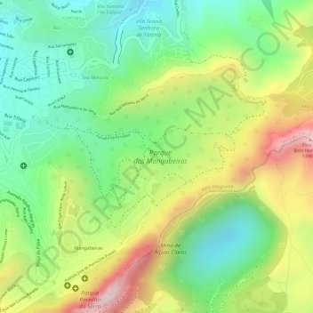
Name: Parque das Mangabeiras topographic map, elevation, terrain.
Average elevation: 3,615 ft
Minimum elevation: 2,966 ft
Maximum elevation: 4,511 ft
Make a donation
Gear up for your next adventure:
As an Amazon Associate, this site earns from qualifying purchases at no extra cost to you.
Other topographic maps
Click on a map to view its topography, its elevation and its terrain.
Make a donation
Gear up for your next adventure:
As an Amazon Associate, this site earns from qualifying purchases at no extra cost to you.
Vila Santa Mônica 1ª Seção
Brasil > Minas Gerais > Belo Horizonte > Vila Santa Mônica 1ª Seção
Average elevation: 2,674 ft
Make a donation
Gear up for your next adventure:
As an Amazon Associate, this site earns from qualifying purchases at no extra cost to you.