
Thank you for supporting this site ❤️
Make a donation
Make a donation
Gear up for your next adventure:
As an Amazon Associate, this site earns from qualifying purchases at no extra cost to you.
Neemrana topographic map
Click on the map to display elevation.
Thank you for supporting this site ❤️
Make a donation
Make a donation
Gear up for your next adventure:
As an Amazon Associate, this site earns from qualifying purchases at no extra cost to you.
About this map
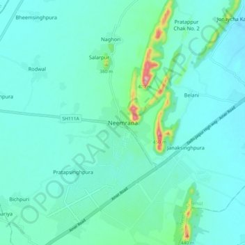
Name: Neemrana topographic map, elevation, terrain.
Location: Neemrana, Neemrana Tehsil, Alwar, Rajasthan, 301705, India (27.95216 76.34566 28.03216 76.42566)
Average elevation: 1,020 ft
Minimum elevation: 928 ft
Maximum elevation: 1,545 ft
Thank you for supporting this site ❤️
Make a donation
Make a donation
Gear up for your next adventure:
As an Amazon Associate, this site earns from qualifying purchases at no extra cost to you.