
Oteppe topographic map
Interactive map
Click on the map to display elevation.
About this map
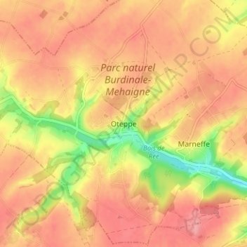
Name: Oteppe topographic map, elevation, terrain.
Location: Oteppe, Burdinne, Hoei, Luik, Wallonië, 4210, België (50.56239 5.10699 50.60239 5.14699)
Average elevation: 531 ft
Minimum elevation: 335 ft
Maximum elevation: 630 ft
Other topographic maps
Click on a map to view its topography, its elevation and its terrain.
Vierset-Barse
Vierset-Barse, Modave, Hoei, Luik, Wallonië, 4577, België
Average elevation: 764 ft
Villers-le-Bouillet
Villers-le-Bouillet, Hoei, Luik, Wallonië, 4530, België
Average elevation: 568 ft
Arrête de Fairon
België > Luik > Hoei > Comblain-la-Tour
Arrête de Fairon, Comblain-la-Tour, Hamoir, Hoei, Luik, Wallonië, 4180, België
Average elevation: 597 ft