
Make a donation
Gear up for your next adventure:
As an Amazon Associate, this site earns from qualifying purchases at no extra cost to you.
Nandrin topographic map
Click on the map to display elevation.
Make a donation
Gear up for your next adventure:
As an Amazon Associate, this site earns from qualifying purchases at no extra cost to you.
About this map
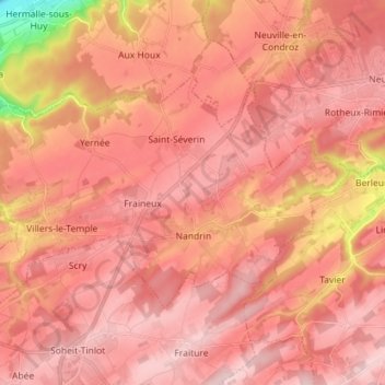
Name: Nandrin topographic map, elevation, terrain.
Location: Nandrin, Hoei, Luik, Wallonië, 4550, België (50.48846 5.33488 50.54389 5.47694)
Average elevation: 748 ft
Minimum elevation: 200 ft
Maximum elevation: 978 ft
Make a donation
Gear up for your next adventure:
As an Amazon Associate, this site earns from qualifying purchases at no extra cost to you.
Other topographic maps
Click on a map to view its topography, its elevation and its terrain.
Marneffe
De thans verdwenen Sint-Remigiuskerk van Marneffe bevond zich ter hoogte van het oude kerkhof. Op 13 mei 1733 gaf kanunnik Henri-Léonard de Charles van de kathedraal van Luik zijn akkoord voor de herbouw van het kerkkoor. Maar ruim een eeuw later, in 1846, werd de kerk afgebroken en vervangen door het…
Average elevation: 509 ft
Make a donation
Gear up for your next adventure:
As an Amazon Associate, this site earns from qualifying purchases at no extra cost to you.
Make a donation
Gear up for your next adventure:
As an Amazon Associate, this site earns from qualifying purchases at no extra cost to you.