Geolocate

Monroe topographic map

Click on the map to display elevation.

About this map

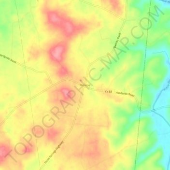
Name: Monroe topographic map, elevation, terrain.

Location: Monroe, Hart County, Kentucky, 42746, United States (37.21228 -85.71775 37.25228 -85.67775)

Average elevation: 689 ft

Minimum elevation: 505 ft

Maximum elevation: 827 ft

Hart County trails, hiking, mountain biking, running and outdoor activities

Other topographic maps

Click on a map to view its topography, its elevation and its terrain.

Munfordville

United States > Kentucky > Hart County

Average elevation: 627 ft

Horse Cave

United States > Kentucky > Hart County

Average elevation: 679 ft

Bonnieville

United States > Kentucky > Hart County

Average elevation: 696 ft

Gear up for your next adventure:

🪶Thermal Camp Blanket - Extra warmth for cold nights
🪓Survival Multi‑Tool - Versatile tool for camp and trail tasks
Backpacking Tent - Lightweight and durable tent for multi‑day hikes
🛠️Outdoor Gear Repair Kit - Essential tools to fix gear on the trail
🔋Solar Power Banks - Keep your GPS and phone charged in remote wilderness areas

As an Amazon Associate, this site earns from qualifying purchases at no extra cost to you.