
Pangrango topographic map
Click on the map to display elevation.
Pangrango
The Mandalawangi peak of the mountain is a tripoint where the borders of Bogor, Cianjur, and Sukabumi Regencies meet. It is the second-highest mountain in West Java after Mount Cereme. Mount Pangrango ranked 26th of the Ribus of Indonesia with a topographic prominence of 2,426 m (7,959 ft). The mountain is seen from Bogor and Sukabumi, while it is slightly obscured by the neighboring Mount Gede if seen from Cianjur. On a very clear day, it can be seen from Jakarta.
About this map
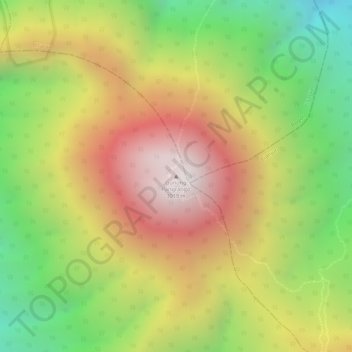
Name: Pangrango topographic map, elevation, terrain.
Location: Pangrango, Sukabumi, West Java, Java, Indonesia (-6.76986 106.96398 -6.76976 106.96408)
Average elevation: 8,173 ft
Minimum elevation: 6,329 ft
Maximum elevation: 9,839 ft
Other topographic maps
Click on a map to view its topography, its elevation and its terrain.
Mount Gede Pangrango National Park
Indonesia > West Java > Sukabumi > Kadudampit
Average elevation: 3,461 ft