Geolocate

Pacifica topographic map

Click on the map to display elevation.

About this map

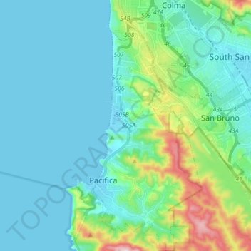
Name: Pacifica topographic map, elevation, terrain.

Location: Pacifica, San Mateo County, California, 94044, USA (37.56633 -122.51533 37.67881 -122.44342)

Average elevation: 266 ft

Minimum elevation: -3 ft

Maximum elevation: 1,496 ft

Gear up for your next adventure:

📖Nature Tracking Books - Learn to track wildlife and terrain
🛶Inflatable Kayak - Portable kayak for rivers, lakes, and expeditions
🧣Hiking Neck Gaiter - Multi‑use neck protection for outdoor weather
📌Outdoor GPS Map App - Apps and devices for digital topographic navigation
🌡️Portable Weather Meter - Track weather conditions on the trail

As an Amazon Associate, this site earns from qualifying purchases at no extra cost to you.