Geolocate

Gugo topographic map

Click on the map to display elevation.

About this map

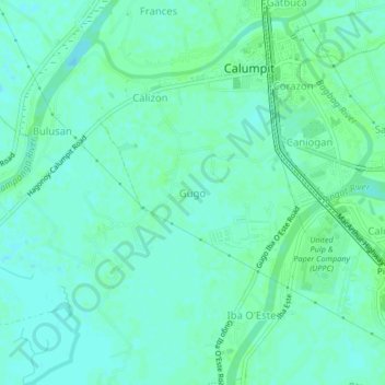
Name: Gugo topographic map, elevation, terrain.

Location: Gugo, Calumpit, Bulacan, Central Luzon, 3003, Philippines (14.88215 120.73753 14.92215 120.77753)

Average elevation: 13 ft

Minimum elevation: 0 ft

Maximum elevation: 23 ft

Other topographic maps

Click on a map to view its topography, its elevation and its terrain.

La Residencia

Philippines > Bulacan > Calumpit > Sergio Bayan

Average elevation: 16 ft

Gear up for your next adventure:

🧷Carabiner Set - Durable clips for gear attachment
🥤Water Filter Bottle - All‑in‑one filter bottle for safe hydration
GPS Sports Watch - GPS watch for running, hiking and training
🎁Geography Themed Gifts - Unique gift ideas for map lovers and geography enthusiasts
👟Men's Trail Runners - Lightweight footwear for fast-paced exploration and light hiking

As an Amazon Associate, this site earns from qualifying purchases at no extra cost to you.