
Make a donation
Gear up for your next adventure:
As an Amazon Associate, this site earns from qualifying purchases at no extra cost to you.
Chasteuil topographic map
Click on the map to display elevation.
Make a donation
Gear up for your next adventure:
As an Amazon Associate, this site earns from qualifying purchases at no extra cost to you.
About this map
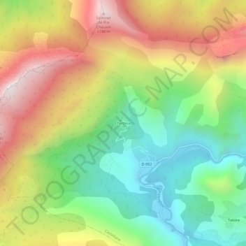
Name: Chasteuil topographic map, elevation, terrain.
Average elevation: 3,750 ft
Minimum elevation: 2,159 ft
Maximum elevation: 5,794 ft
Make a donation
Gear up for your next adventure:
As an Amazon Associate, this site earns from qualifying purchases at no extra cost to you.
Other topographic maps
Click on a map to view its topography, its elevation and its terrain.
Lac de Chaudanne
France > Provence-Alpes-Côte d'Azur > Alpes-de-Haute-Provence > Castellane > La Lagne
Average elevation: 3,297 ft
Lac de Chaudanne
France > Provence-Alpes-Côte d'Azur > Alpes-de-Haute-Provence > Castellane > La Lagne
Average elevation: 3,304 ft
Lac de Chaudanne
France > Provence-Alpes-Côte d'Azur > Alpes-de-Haute-Provence > Castellane > La Lagne
Average elevation: 3,304 ft