Geolocate

Kobuleti topographic map

Click on the map to display elevation.

About this map

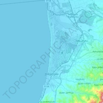
Name: Kobuleti topographic map, elevation, terrain.

Location: Kobuleti, Kobuleti Municipality, Autonomous Republic of Adjara, 6200, Georgia (41.77129 41.75485 41.91193 41.83568)

Average elevation: 69 ft

Minimum elevation: -16 ft

Maximum elevation: 1,854 ft

Other topographic maps

Click on a map to view its topography, its elevation and its terrain.

Gear up for your next adventure:

🛰️Satellite Messengers - Emergency SOS and two-way messaging for off-grid adventures
🥾Women's Hiking Boots - Top-rated trail boots with ankle support and superior grip
🦺Reflective Outdoor Gear - Safety gear for low‑light conditions
🪶Fire Starter Kit - Reliable fire starter for survival and camping
🔌Solar Panel Charger - Charge gear sustainably outdoors

As an Amazon Associate, this site earns from qualifying purchases at no extra cost to you.