
Make a donation
Gear up for your next adventure:
As an Amazon Associate, this site earns from qualifying purchases at no extra cost to you.
Dolgelin topographic map
Click on the map to display elevation.
Make a donation
Gear up for your next adventure:
As an Amazon Associate, this site earns from qualifying purchases at no extra cost to you.
Dolgelin
Dolgelin ist eines der ältesten Höhendörfer am Westrand des Oderbruches. Grabungen seit dem Jahre 2000 brachten Besiedlungsspuren aus der Bronze- und Eisenzeit ans Tageslicht.
Make a donation
Gear up for your next adventure:
As an Amazon Associate, this site earns from qualifying purchases at no extra cost to you.
About this map
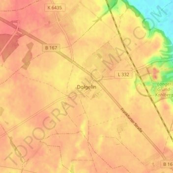
Name: Dolgelin topographic map, elevation, terrain.
Average elevation: 164 ft
Minimum elevation: 26 ft
Maximum elevation: 217 ft
Make a donation
Gear up for your next adventure:
As an Amazon Associate, this site earns from qualifying purchases at no extra cost to you.
Other topographic maps
Click on a map to view its topography, its elevation and its terrain.
Dolgelin
Deutschland > Brandenburg > Märkisch-Oderland > Lindendorf
Dolgelin ist eines der ältesten Höhendörfer am Westrand des Oderbruches. Grabungen seit dem Jahre 2000 brachten Besiedlungsspuren aus der Bronze- und Eisenzeit ans Tageslicht.
Average elevation: 141 ft