
Thank you for supporting this site ❤️
Make a donation
Make a donation
Gear up for your next adventure:
As an Amazon Associate, this site earns from qualifying purchases at no extra cost to you.
Westerbork topographic map
Click on the map to display elevation.
Thank you for supporting this site ❤️
Make a donation
Make a donation
Gear up for your next adventure:
As an Amazon Associate, this site earns from qualifying purchases at no extra cost to you.
About this map
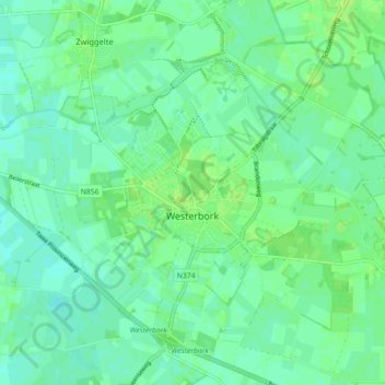
Name: Westerbork topographic map, elevation, terrain.
Location: Westerbork, Midden-Drenthe, Drenthe, Netherlands (52.83384 6.55452 52.87090 6.64336)
Average elevation: 52 ft
Minimum elevation: 36 ft
Maximum elevation: 72 ft
Thank you for supporting this site ❤️
Make a donation
Make a donation
Gear up for your next adventure:
As an Amazon Associate, this site earns from qualifying purchases at no extra cost to you.