
Make a donation
Gear up for your next adventure:
As an Amazon Associate, this site earns from qualifying purchases at no extra cost to you.
San Sebastián de los Reyes topographic map
Click on the map to display elevation.
Make a donation
Gear up for your next adventure:
As an Amazon Associate, this site earns from qualifying purchases at no extra cost to you.
About this map
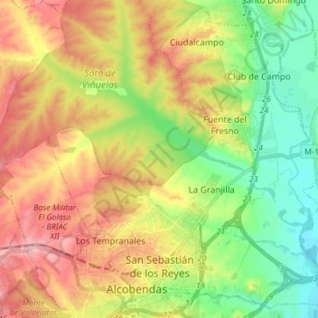
Name: San Sebastián de los Reyes topographic map, elevation, terrain.
Location: San Sebastián de los Reyes, Community of Madrid, Spain (40.53320 -3.67409 40.63101 -3.53788)
Average elevation: 2,159 ft
Minimum elevation: 1,906 ft
Maximum elevation: 2,470 ft
Make a donation
Gear up for your next adventure:
As an Amazon Associate, this site earns from qualifying purchases at no extra cost to you.
Other topographic maps
Click on a map to view its topography, its elevation and its terrain.
Make a donation
Gear up for your next adventure:
As an Amazon Associate, this site earns from qualifying purchases at no extra cost to you.
Alcorcón
Spain > Community of Madrid > Área metropolitana de Madrid y Corredor del Henares > Alcorcón
Average elevation: 2,119 ft
La Castellana y El Pilar
Spain > Community of Madrid > Sierra Oeste > Cadalso de los Vidrios
Average elevation: 2,585 ft