
Make a donation
Gear up for your next adventure:
As an Amazon Associate, this site earns from qualifying purchases at no extra cost to you.
Fochabers topographic map
Click on the map to display elevation.
Make a donation
Gear up for your next adventure:
As an Amazon Associate, this site earns from qualifying purchases at no extra cost to you.
Fochabers
The present village owes its existence to the 4th Duke of Gordon (1743–1827). During the late eighteenth century, during the Scottish Enlightenment, it was fashionable for landowners to found new towns and villages; these can be recognised all over Scotland, because unlike their predecessors they all have straight, wide streets in mainly rectangular layouts, a central square, and the houses built with their main elevations parallel to the street.
Make a donation
Gear up for your next adventure:
As an Amazon Associate, this site earns from qualifying purchases at no extra cost to you.
About this map
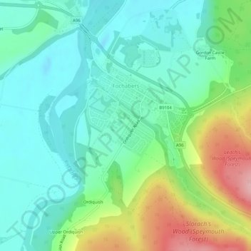
Name: Fochabers topographic map, elevation, terrain.
Location: Fochabers, Moray, Scotland, United Kingdom (57.60078 -3.10873 57.61875 -3.08369)
Average elevation: 194 ft
Minimum elevation: 43 ft
Maximum elevation: 558 ft
Make a donation
Gear up for your next adventure:
As an Amazon Associate, this site earns from qualifying purchases at no extra cost to you.