
Thank you for supporting this site ❤️
Make a donation
Make a donation
Gear up for your next adventure:
As an Amazon Associate, this site earns from qualifying purchases at no extra cost to you.
Mitundu topographic map
Click on the map to display elevation.
Thank you for supporting this site ❤️
Make a donation
Make a donation
Gear up for your next adventure:
As an Amazon Associate, this site earns from qualifying purchases at no extra cost to you.
About this map
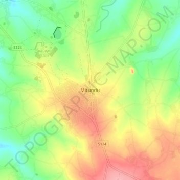
Name: Mitundu topographic map, elevation, terrain.
Location: Mitundu, Lilongwe, Central Region, Malawi, Malawi (-14.28867 33.73877 -14.20867 33.81877)
Average elevation: 3,907 ft
Minimum elevation: 3,753 ft
Maximum elevation: 4,085 ft
Thank you for supporting this site ❤️
Make a donation
Make a donation
Gear up for your next adventure:
As an Amazon Associate, this site earns from qualifying purchases at no extra cost to you.