
Blair Township topographic map
Interactive map
Click on the map to display elevation.
About this map
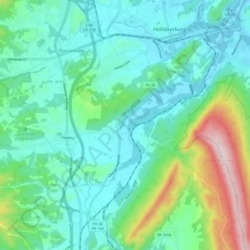
Name: Blair Township topographic map, elevation, terrain.
Location: Blair Township, Blair County, Pennsylvania, United States (40.35518 -78.45568 40.44057 -78.35780)
Average elevation: 1,273 ft
Minimum elevation: 915 ft
Maximum elevation: 2,500 ft
Blair County trails, hiking, mountain biking, running and outdoor activities
Other topographic maps
Click on a map to view its topography, its elevation and its terrain.
East Freedom
United States > Pennsylvania > Blair County > Freedom Township
Average elevation: 1,217 ft
Yellow Spring
United States > Pennsylvania > Blair County > Catharine Township
Average elevation: 1,175 ft
Beverly Hills
United States > Pennsylvania > Blair County > Logan Township
Average elevation: 1,424 ft
Charlottsville
United States > Pennsylvania > Blair County > Antis Township
Average elevation: 1,148 ft
Frankstown
United States > Pennsylvania > Blair County > Frankstown Township
Average elevation: 1,053 ft