
Make a donation
Gear up for your next adventure:
As an Amazon Associate, this site earns from qualifying purchases at no extra cost to you.
Montbard topographic map
Click on the map to display elevation.
Make a donation
Gear up for your next adventure:
As an Amazon Associate, this site earns from qualifying purchases at no extra cost to you.
About this map
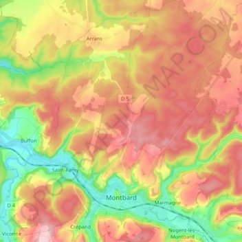
Name: Montbard topographic map, elevation, terrain.
Average elevation: 981 ft
Minimum elevation: 646 ft
Maximum elevation: 1,270 ft
Make a donation
Gear up for your next adventure:
As an Amazon Associate, this site earns from qualifying purchases at no extra cost to you.
Other topographic maps
Click on a map to view its topography, its elevation and its terrain.
Lac de Pont
France > Bourgogne-Franche-Comté > Côte-d'Or > Le Val-Larrey > Allerey
Average elevation: 1,099 ft
Hameau de Chausseroze
France > Bourgogne-Franche-Comté > Côte-d'Or > Vic-sous-Thil
Average elevation: 1,224 ft
Combe Gisset
France > Bourgogne-Franche-Comté > Côte-d'Or > Plombières-lès-Dijon > La Cras
Average elevation: 1,076 ft
Source de la Boïse
France > Bourgogne-Franche-Comté > Côte-d'Or > Gevrey-Chambertin > Rente de L'Epoy
Average elevation: 810 ft
Make a donation
Gear up for your next adventure:
As an Amazon Associate, this site earns from qualifying purchases at no extra cost to you.
Concœur
France > Bourgogne-Franche-Comté > Côte-d'Or > Nuits-Saint-Georges
Average elevation: 1,266 ft
Le Petit Cirey
France > Bourgogne-Franche-Comté > Côte-d'Or > Nolay > Le Petit Cirey
Average elevation: 1,365 ft