
Make a donation
Gear up for your next adventure:
As an Amazon Associate, this site earns from qualifying purchases at no extra cost to you.
Glessen topographic map
Click on the map to display elevation.
Make a donation
Gear up for your next adventure:
As an Amazon Associate, this site earns from qualifying purchases at no extra cost to you.
Glessen
Glessen liegt unterhalb der Glessener Höhe am Ostabhang der Ville am Rande des Naturpark Rheinland und nordwestlich von Köln. Oberhalb des Ortes entspringt beim Gut Neuhof der Pulheimer Bach, hier noch Glessener Bach genannt, der in Glessen früher zwei Wassermühlen antrieb. Im Ort treffen sich die Landstraßen 91 und 213.
Make a donation
Gear up for your next adventure:
As an Amazon Associate, this site earns from qualifying purchases at no extra cost to you.
About this map
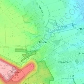
Name: Glessen topographic map, elevation, terrain.
Average elevation: 348 ft
Minimum elevation: 203 ft
Maximum elevation: 679 ft
Make a donation
Gear up for your next adventure:
As an Amazon Associate, this site earns from qualifying purchases at no extra cost to you.
Other topographic maps
Click on a map to view its topography, its elevation and its terrain.