
Kessel-Eik topographic map
Interactive map
Click on the map to display elevation.
About this map
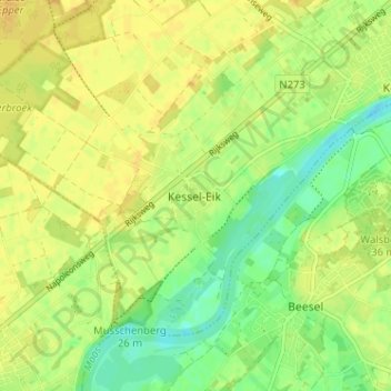
Name: Kessel-Eik topographic map, elevation, terrain.
Location: Kessel-Eik, Limburg, Nederland, 5995NP, Nederland (51.26019 6.00389 51.30019 6.04389)
Average elevation: 85 ft
Minimum elevation: 39 ft
Maximum elevation: 112 ft
Other topographic maps
Click on a map to view its topography, its elevation and its terrain.
Hei
Nederland > Limburg > Kessel-Eik
Hei, Kessel-Eik, Kessel, Peel en Maas, Limburg, Nederland, 5995 SH, Nederland
Average elevation: 89 ft