Geolocate

Luray topographic map

Click on the map to display elevation.

About this map

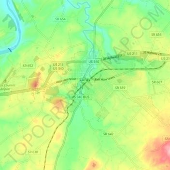
Name: Luray topographic map, elevation, terrain.

Location: Luray, Page County, Virginia, 22835, United States (38.64795 -78.50739 38.67804 -78.41778)

Average elevation: 876 ft

Minimum elevation: 689 ft

Maximum elevation: 1,148 ft

Page County trails, hiking, mountain biking, running and outdoor activities

Other topographic maps

Click on a map to view its topography, its elevation and its terrain.

Rileyville

United States > Virginia > Page County

Average elevation: 801 ft

Luray Caverns

United States > Virginia > Page County > Luray

Average elevation: 909 ft

Shenandoah Forest

United States > Virginia > Page County

Average elevation: 1,217 ft

Ida

United States > Virginia > Page County

Average elevation: 1,516 ft

Gear up for your next adventure:

🧺Microfiber Travel Towels - Compact and fast-drying towels for trail use
🪶Fire Starter Kit - Reliable fire starter for survival and camping
🗃️Trail First Aid Kit - Essential kit for outdoor injuries and emergencies
🎒Hydration Pack - Hands‑free water reservoir for long hikes
🔥Fast-Boil Camping Stoves - Efficient cooking systems for quick trail meals

As an Amazon Associate, this site earns from qualifying purchases at no extra cost to you.