
Rileyville topographic map
Click on the map to display elevation.
About this map
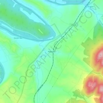
Name: Rileyville topographic map, elevation, terrain.
Location: Rileyville, Page County, Virginia, 22650, United States (38.74441 -78.40756 38.78441 -78.36756)
Average elevation: 801 ft
Minimum elevation: 587 ft
Maximum elevation: 1,299 ft
Page County trails, hiking, mountain biking, running and outdoor activities
Other topographic maps
Click on a map to view its topography, its elevation and its terrain.
Shenandoah National Park
United States > Virginia > Page County
Shenandoah National Park lies along the Blue Ridge Mountains in north-central Virginia. These mountains form a distinct highland rising to elevations above 4,000 feet (1,200 m). Local topographic relief between the Blue Ridge Mountains and Shenandoah Valley exceeds 3,000 feet (910 m) at some locations. The…
Average elevation: 1,099 ft
Shenandoah National Park
United States > Virginia > Page County
Shenandoah National Park lies along the Blue Ridge Mountains in north-central Virginia. These mountains form a distinct highland rising to elevations above 4,000 feet (1,200 m). Local topographic relief between the Blue Ridge Mountains and Shenandoah Valley exceeds 3,000 feet (900 m) at some locations. The…
Average elevation: 1,099 ft