
Thank you for supporting this site ❤️
Make a donation
Make a donation
Gear up for your next adventure:
As an Amazon Associate, this site earns from qualifying purchases at no extra cost to you.
Consacá topographic map
Click on the map to display elevation.
Thank you for supporting this site ❤️
Make a donation
Make a donation
Gear up for your next adventure:
As an Amazon Associate, this site earns from qualifying purchases at no extra cost to you.
About this map
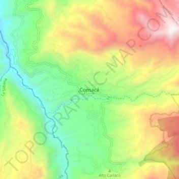
Name: Consacá topographic map, elevation, terrain.
Location: Consacá, Occidente, Nariño, Colombia (1.16828 -77.50561 1.24828 -77.42561)
Average elevation: 6,329 ft
Minimum elevation: 3,717 ft
Maximum elevation: 9,961 ft
Thank you for supporting this site ❤️
Make a donation
Make a donation
Gear up for your next adventure:
As an Amazon Associate, this site earns from qualifying purchases at no extra cost to you.