
Make a donation
Gear up for your next adventure:
As an Amazon Associate, this site earns from qualifying purchases at no extra cost to you.
Mahal topographic map
Click on the map to display elevation.
Make a donation
Gear up for your next adventure:
As an Amazon Associate, this site earns from qualifying purchases at no extra cost to you.
About this map
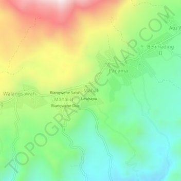
Name: Mahal topographic map, elevation, terrain.
Average elevation: 1,158 ft
Minimum elevation: 131 ft
Maximum elevation: 2,848 ft
Make a donation
Gear up for your next adventure:
As an Amazon Associate, this site earns from qualifying purchases at no extra cost to you.
Other topographic maps
Click on a map to view its topography, its elevation and its terrain.
Lembata Island
Indonesia > East Nusa Tenggara > Lembata
Lembata is an island in the Lesser Sunda Islands, also known as Lomblen island; it is the largest island of the Solor Archipelago, in the Lesser Sunda Islands, Indonesia. It forms a separate regency of the province of Nusa Tenggara Timur. The island has a very irregular coastline with numerous bays and…
Average elevation: 230 ft