
Thank you for supporting this site ❤️
Make a donation
Make a donation
Gear up for your next adventure:
As an Amazon Associate, this site earns from qualifying purchases at no extra cost to you.
Benasa topographic map
Click on the map to display elevation.
Thank you for supporting this site ❤️
Make a donation
Make a donation
Gear up for your next adventure:
As an Amazon Associate, this site earns from qualifying purchases at no extra cost to you.
About this map
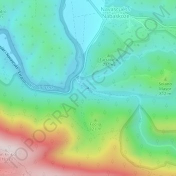
Name: Benasa topographic map, elevation, terrain.
Location: Benasa, Navascués / Nabaskoze, Pirinioak, 31454, Spain (42.70689 -1.12184 42.70700 -1.12178)
Average elevation: 2,434 ft
Minimum elevation: 1,844 ft
Maximum elevation: 3,845 ft
Thank you for supporting this site ❤️
Make a donation
Make a donation
Gear up for your next adventure:
As an Amazon Associate, this site earns from qualifying purchases at no extra cost to you.