
Make a donation
Gear up for your next adventure:
As an Amazon Associate, this site earns from qualifying purchases at no extra cost to you.
Carvers topographic map
Click on the map to display elevation.
Make a donation
Gear up for your next adventure:
As an Amazon Associate, this site earns from qualifying purchases at no extra cost to you.
Carvers
Carvers (also known as Carvers Station) is an unincorporated community in Nye County, Nevada, United States. Its elevation is 5,643 feet (1,720 m). Carvers is the northernmost of the three settlements that make up the Big Smoky Valley's Round Mountain mining region. Its zip code is 89045.
Make a donation
Gear up for your next adventure:
As an Amazon Associate, this site earns from qualifying purchases at no extra cost to you.
About this map
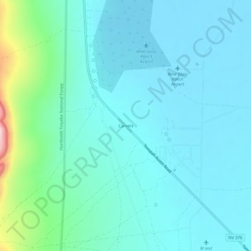
Name: Carvers topographic map, elevation, terrain.
Location: Carvers, Nye County, Nevada, United States (38.76246 -117.19369 38.80246 -117.15369)
Average elevation: 5,669 ft
Minimum elevation: 5,551 ft
Maximum elevation: 6,115 ft
Nye County trails, hiking, mountain biking, running and outdoor activities
Make a donation
Gear up for your next adventure:
As an Amazon Associate, this site earns from qualifying purchases at no extra cost to you.
Other topographic maps
Click on a map to view its topography, its elevation and its terrain.