
Make a donation
Gear up for your next adventure:
As an Amazon Associate, this site earns from qualifying purchases at no extra cost to you.
Grizac topographic map
Click on the map to display elevation.
Make a donation
Gear up for your next adventure:
As an Amazon Associate, this site earns from qualifying purchases at no extra cost to you.
About this map
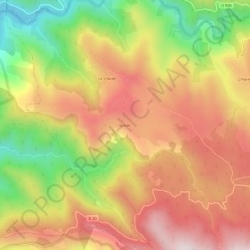
Name: Grizac topographic map, elevation, terrain.
Average elevation: 3,219 ft
Minimum elevation: 2,146 ft
Maximum elevation: 4,081 ft
Make a donation
Gear up for your next adventure:
As an Amazon Associate, this site earns from qualifying purchases at no extra cost to you.
Other topographic maps
Click on a map to view its topography, its elevation and its terrain.
Le Pont-de-Montvert
France > Occitanie > Lozère > Pont de Montvert - Sud Mont Lozère
Average elevation: 4,016 ft
Saint-Maurice-de-Ventalon
France > Occitanie > Lozère > Pont de Montvert - Sud Mont Lozère
Situé sur le cours du Luech, le bourg est au pied du versant nord de la montagne du Bougès, un contrefort du mont Lozère - ce dernier se trouvant dans la partie nord de la commune voisine, Le Pont-de-Montvert. La ligne de crêtes du Bougès est orientée est-ouest. Elle forme la limite de communes entre Le…
Average elevation: 3,793 ft
Fraissinet-de-Lozère
France > Occitanie > Lozère > Pont de Montvert - Sud Mont Lozère
Average elevation: 4,009 ft
Tourbiere du lac
France > Occitanie > Lozère > Pont de Montvert - Sud Mont Lozère
Average elevation: 3,609 ft
Make a donation
Gear up for your next adventure:
As an Amazon Associate, this site earns from qualifying purchases at no extra cost to you.
Le Pont-de-Montvert
France > Occitanie > Lozère > Pont de Montvert - Sud Mont Lozère
Average elevation: 4,016 ft
Saint-Maurice-de-Ventalon
France > Occitanie > Lozère > Pont de Montvert - Sud Mont Lozère
Situé sur le cours du Luech, le bourg est au pied du versant nord de la montagne du Bougès, un contrefort du mont Lozère - ce dernier se trouvant dans la partie nord de la commune voisine, Le Pont-de-Montvert. La ligne de crêtes du Bougès est orientée est-ouest. Elle forme la limite de communes entre Le…
Average elevation: 3,793 ft