
Make a donation
Gear up for your next adventure:
As an Amazon Associate, this site earns from qualifying purchases at no extra cost to you.
Vlimmeren topographic map
Click on the map to display elevation.
Make a donation
Gear up for your next adventure:
As an Amazon Associate, this site earns from qualifying purchases at no extra cost to you.
Vlimmeren
Vlimmeren ligt in de Antwerpse Kempen op een hoogte van 17-28 meter. Natuurgebieden in de omgeving zijn Heihuizen, Visbeekvallei-Kindernouw, Epelaar en Duivelskuil.
Make a donation
Gear up for your next adventure:
As an Amazon Associate, this site earns from qualifying purchases at no extra cost to you.
About this map
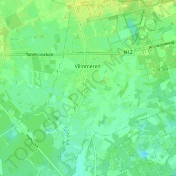
Name: Vlimmeren topographic map, elevation, terrain.
Location: Vlimmeren, Beerse, Turnhout, Antwerpen, Vlaanderen, België (51.27315 4.76550 51.31439 4.81739)
Average elevation: 66 ft
Minimum elevation: 43 ft
Maximum elevation: 92 ft
Make a donation
Gear up for your next adventure:
As an Amazon Associate, this site earns from qualifying purchases at no extra cost to you.