
Thank you for supporting this site ❤️
Make a donation
Make a donation
Gear up for your next adventure:
As an Amazon Associate, this site earns from qualifying purchases at no extra cost to you.
Danilo Biranj topographic map
Click on the map to display elevation.
Thank you for supporting this site ❤️
Make a donation
Make a donation
Gear up for your next adventure:
As an Amazon Associate, this site earns from qualifying purchases at no extra cost to you.
About this map
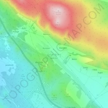
Name: Danilo Biranj topographic map, elevation, terrain.
Location: Danilo Biranj, Šibenik-Knin County, Croatia (43.70729 15.97395 43.74729 16.01395)
Average elevation: 797 ft
Minimum elevation: 344 ft
Maximum elevation: 1,637 ft
Thank you for supporting this site ❤️
Make a donation
Make a donation
Gear up for your next adventure:
As an Amazon Associate, this site earns from qualifying purchases at no extra cost to you.