
Make a donation
Gear up for your next adventure:
As an Amazon Associate, this site earns from qualifying purchases at no extra cost to you.
Southern Leyte topographic map
Click on the map to display elevation.
Make a donation
Gear up for your next adventure:
As an Amazon Associate, this site earns from qualifying purchases at no extra cost to you.
Southern Leyte
Along with other mountain forms in the province, Mount Nacolod in Hinunangan town has the highest peak with an elevation of 948 metres (3,110 ft) above sea level. Young volcanic rocks are discovered in the terrain areas, which cover the top of the southern mountain ranges of Mount Cabalian in the Pacific Area and Mount Nelangcapan in Panaon Area.
Make a donation
Gear up for your next adventure:
As an Amazon Associate, this site earns from qualifying purchases at no extra cost to you.
About this map
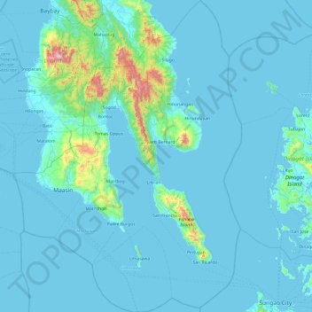
Name: Southern Leyte topographic map, elevation, terrain.
Location: Southern Leyte, Eastern Visayas, Philippines (9.76033 124.68340 10.70524 125.39128)
Average elevation: 217 ft
Minimum elevation: -3 ft
Maximum elevation: 3,635 ft
Make a donation
Gear up for your next adventure:
As an Amazon Associate, this site earns from qualifying purchases at no extra cost to you.
Other topographic maps
Click on a map to view its topography, its elevation and its terrain.
Baguio
In 1903, Filipinos, Japanese and Chinese workers were hired to build Kennon Road, the first road directly connecting Baguio with the lowlands of La Union and Pangasinan. Before this, the only road to Benguet was Naguilian Road, and it was largely a horse trail at higher elevations. Camp John Hay was…
Average elevation: 2,890 ft
Quezon City
Founded as a pueblo by Saint Pedro Bautista in 1590, San Francisco del Monte may be considered Quezon City's oldest district. The original land area of the old town of San Francisco del Monte was approximately2.5 square kilometres (1.0 sq mi) and covered parts of what is currently known as Project 7 and 8 and…
Average elevation: 187 ft
Make a donation
Gear up for your next adventure:
As an Amazon Associate, this site earns from qualifying purchases at no extra cost to you.
Vigan
Vigan is situated in a Quaternary Age sedimentary plain called the Vigan-Bantay Plain which is part of the Ilocos coastal plain. The Vigan-Bantay Plain is bounded on the east by a moderately rugged Miocene sediments consisting of interbedded sandstones and shale to very rugged Meta-volcanics and Meta sediment…
Average elevation: 207 ft
Malolos
Malolos is relatively flat of about 0.81% to a gently sloping of 2.17%. The slope of the land descends towards west, southwest to southern direction. The highest land elevation is at about 6.0 meters above sea level while the lowest is only half a meter below sea level. A network of natural waterways and…
Average elevation: 20 ft
Make a donation
Gear up for your next adventure:
As an Amazon Associate, this site earns from qualifying purchases at no extra cost to you.
Make a donation
Gear up for your next adventure:
As an Amazon Associate, this site earns from qualifying purchases at no extra cost to you.
Cabadbaran
Philippines > Agusan del Norte
It is 29 kilometres (18 mi) from Butuan. It is generally flat with rolling hills and swamplands in its western part. The highest of all mountains in the Caraga region, Mount Hilong-Hilong (with an altitude of 2,012 metres (6,601 ft) above sea level), rises in this city.
Average elevation: 587 ft
Make a donation
Gear up for your next adventure:
As an Amazon Associate, this site earns from qualifying purchases at no extra cost to you.
Trece Martires
The city of Trece Martires is characterised with ground elevation ranging from 30m to nearly 400m. Its ground slope ranges from 0.5 to 2%.
Average elevation: 492 ft
Claveria
Philippines > Misamis Oriental
The town has a generally rugged topography, characterized by gently rolling hills and mountains with cliffs and escarpments. The soil is classified as Jasaan clay, with a deep soil profile (greater than 1 m) and rapid drainage. It is generally acidic (pH 3.9 to 5.2), with low cation exchange capacity (CEC),…
Average elevation: 2,175 ft
Make a donation
Gear up for your next adventure:
As an Amazon Associate, this site earns from qualifying purchases at no extra cost to you.
Daraga
67.3% of the total municipal land area has a predominantly low elevation of up to 100 metres (330 ft). The surface terrain is generally characterized by combination of level to nearly level areas, gentle to undulating areas and undulating to rolling areas.
Average elevation: 249 ft
Lake Sebu
The placid lake of Lake Sebu can be found in Allah Valley near the municipality of Surallah, South Cotabato. Surrounded by rolling hills and mountains covered with thick rain forest, the lake has an area of 361.124 hectares (892.36 acres), with an elevation of approximately 1,000 metres (3,300 ft).
Average elevation: 2,461 ft
Make a donation
Gear up for your next adventure:
As an Amazon Associate, this site earns from qualifying purchases at no extra cost to you.
Make a donation
Gear up for your next adventure:
As an Amazon Associate, this site earns from qualifying purchases at no extra cost to you.
Legazpi
Legazpi's topography is generally plain on the northeastern areas, with slopes ranging from five to fifteen degrees. The southern areas have mostly rolling to hilly terrain. In the city's coastal areas, the terrain varies from plain (north) to hilly (south). Legazpi is criss-crossed by several rivers including…
Average elevation: 492 ft
Make a donation
Gear up for your next adventure:
As an Amazon Associate, this site earns from qualifying purchases at no extra cost to you.
Bacolod
Bacólod (English: Bacolod), is derived from bakólod (Old Spelling: bacólod), the Old Hiligaynon (Old Ilonggo) (Old Spelling: Ylongo and Ilongo) word for a "hill, turtle, mound, rise, hillock, down, any small eminence or elevation", since the resettlement was founded on a stony, hilly area, now the barangay…
Average elevation: 161 ft
Mandaluyong
Another claims that the Spaniards named the place based on the report of a navigator named Acapulco, who saw the rolling hills frequently being lashed at by daluyong (“big waves from the sea”). This seems to confirm traditional pre-Hispanic stories that giant waves from the sea would meet the adjoining…
Average elevation: 108 ft
Calbayog
Philippines > Samar > Calbayog
Forty percent of the city's land area are plain and hilly terrains with elevation ranging from 5 to 20 metres (16 to 66 ft) above sea level. The rest are rugged mountain ranges with elevations from 300 to 700 metres (980 to 2,300 ft) above sea level. Flooding is minimized because of many rivers, brooks,…
Average elevation: 180 ft
Make a donation
Gear up for your next adventure:
As an Amazon Associate, this site earns from qualifying purchases at no extra cost to you.
Laguna-Quezon Land Grant Lagoon
Philippines > Quezon > Real > Magsaysay > Maunlad
Average elevation: 1,276 ft
Make a donation
Gear up for your next adventure:
As an Amazon Associate, this site earns from qualifying purchases at no extra cost to you.
Make a donation
Gear up for your next adventure:
As an Amazon Associate, this site earns from qualifying purchases at no extra cost to you.
Make a donation
Gear up for your next adventure:
As an Amazon Associate, this site earns from qualifying purchases at no extra cost to you.
Make a donation
Gear up for your next adventure:
As an Amazon Associate, this site earns from qualifying purchases at no extra cost to you.
Antipolo
Its higher elevation than that of Metro Manila affords it a scenic view of the metropolis, especially at night. Its locally grown mangoes and cashews are popular among tourists, as well as suman – a local delicacy made out of glutinous rice. The Hinulugang Taktak National Park, which was once a popular…
Average elevation: 410 ft
Mount Halcon
Philippines > Oriental Mindoro
Mount Halcon (Filipino: Bundok Halcon) and (Spanish: Monte Halcón) is the highest mountain in Mindoro. According to the new data released by Oriental Mindoro peakvisor as of 2022, it has an elevation of 2,616 metres (8,583 ft) above sea level, higher than the previous estimates of 2,586 m (8,484 ft) although…
Average elevation: 6,959 ft
Make a donation
Gear up for your next adventure:
As an Amazon Associate, this site earns from qualifying purchases at no extra cost to you.
Make a donation
Gear up for your next adventure:
As an Amazon Associate, this site earns from qualifying purchases at no extra cost to you.
Make a donation
Gear up for your next adventure:
As an Amazon Associate, this site earns from qualifying purchases at no extra cost to you.
Make a donation
Gear up for your next adventure:
As an Amazon Associate, this site earns from qualifying purchases at no extra cost to you.
Mount Pulag
At lower elevations, Mount Pulag has a mossy forest full of ferns, lichens, and moss.
Average elevation: 8,438 ft
Make a donation
Gear up for your next adventure:
As an Amazon Associate, this site earns from qualifying purchases at no extra cost to you.
Zamboanga City
Philippines > Zamboanga Peninsula > Zamboanga City
The overall topography of the city could be described as rolling to very steep. There are some flat lands, mostly narrow strips along the east coast. The urban center is mostly flat with a gentle slope to the interior, ranging from 0 to 3%. The highest registered elevation is 1,200 metres. In terms of slope, a…
Average elevation: 272 ft
Make a donation
Gear up for your next adventure:
As an Amazon Associate, this site earns from qualifying purchases at no extra cost to you.
Make a donation
Gear up for your next adventure:
As an Amazon Associate, this site earns from qualifying purchases at no extra cost to you.
San Juan
"San Juan" is a contraction of the city's traditional name of "San Juan del Monte" (lit. 'Saint John of the Mountain'). As with numerous other places in the Philippines, the name combines a patron saint and a toponym; in this case Saint John the Baptist with the locale's hilly terrain and relatively higher…
Average elevation: 115 ft
Mount Makiling
Philippines > Laguna > Los Baños
Mount Makiling (also spelled Maquiling) is an inactive stratovolcano located in the provinces of Laguna and Batangas on the island of Luzon in the Philippines. The mountain rises to an elevation of 1,090 meters (3,580 ft) above mean sea level and is the highest feature of the Laguna Volcanic Field. The volcano…
Average elevation: 2,470 ft
Make a donation
Gear up for your next adventure:
As an Amazon Associate, this site earns from qualifying purchases at no extra cost to you.
Make a donation
Gear up for your next adventure:
As an Amazon Associate, this site earns from qualifying purchases at no extra cost to you.
Make a donation
Gear up for your next adventure:
As an Amazon Associate, this site earns from qualifying purchases at no extra cost to you.
Make a donation
Gear up for your next adventure:
As an Amazon Associate, this site earns from qualifying purchases at no extra cost to you.
Make a donation
Gear up for your next adventure:
As an Amazon Associate, this site earns from qualifying purchases at no extra cost to you.