
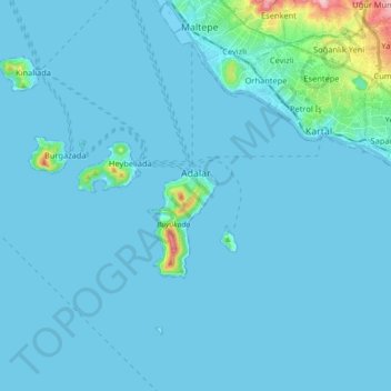
Prince Islands topographic map
Click on the map to display elevation.
Prince Islands
All islands contain hills, the highest being Büyükada's Aya Yorgi Hill with 203 meters of elevation.
About this map
Name: Prince Islands topographic map, elevation, terrain.
Location: Prince Islands, Istanbul, Marmara Region, Turkey (40.81803 28.96917 40.91449 29.14822)
Average elevation: 39 ft
Minimum elevation: -10 ft
Maximum elevation: 715 ft
Other topographic maps
Click on a map to view its topography, its elevation and its terrain.