
Make a donation
Gear up for your next adventure:
As an Amazon Associate, this site earns from qualifying purchases at no extra cost to you.
Karditsa topographic map
Click on the map to display elevation.
Make a donation
Gear up for your next adventure:
As an Amazon Associate, this site earns from qualifying purchases at no extra cost to you.
About this map
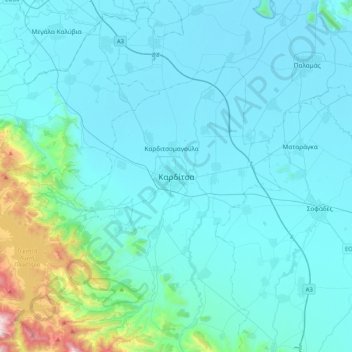
Name: Karditsa topographic map, elevation, terrain.
Average elevation: 758 ft
Minimum elevation: 282 ft
Maximum elevation: 5,433 ft
Make a donation
Gear up for your next adventure:
As an Amazon Associate, this site earns from qualifying purchases at no extra cost to you.
Other topographic maps
Click on a map to view its topography, its elevation and its terrain.
Municipal Unit of Tamasi
Greece > Thessaly and Central Greece > Karditsa Regional Unit
Average elevation: 961 ft
Plastiras (Tavropos) Lake
Greece > Thessaly and Central Greece > Karditsa Regional Unit > Plastiras Municipal Unit
Today the lake holds up to 400 million cubic meters of fresh water. It is used for irrigation and as a power source of a hydroelectric plant, but also as the main water source to the city of Karditsa. Due to its altitude (one of the highest in Europe) the Tavropos Reservoir is a popular tourist resort in…
Average elevation: 2,598 ft